

The Streams of Sligo
by Pierre Perrolle
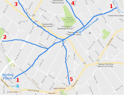 There was once a major spring located between the buildings on Blair Road and the Takoma Metro Station. If you look around, you will not find a spring there but only Spring Place, off Chestnut Ave on the DC side. The spring, once an important source of water for the neighborhood near the train station, was suppressed during the construction of Metro. Its water now flows underground across the (now) Metro Parking lot, across Eastern (at its low point), Tulip (low point) and down the deep valley between Holly and Cedar (one of the reasons the lots between those avenues are extra deep), along Barclay Place, crossing Birch, Phoebe Kelly's Park, and Dogwood, then down Cedar to eventually flow down Maple all the way to Sligo Creek. All the water now runs through storm sewers (you can follow the curb drains along that path and even listen to the water flowing!) If you stand on Sligo Creek Parkway at the little bridge, you can see the two huge exit pipes between the Parkway and the Essex House apartments. Along Maple before it was piped, it was definitely called Brashear's Creek/Branch/Run. There were in fact dirt roads on both sides and little bridges connecting them. How far upstream the name Brashear was used is unclear.
- Several lesser streams flowed into Brashear's Creek in the vicinity of Cedar, Dogwood and Philadelphia. One flowed from the Metro tracks (at Takoma and Buffalo Avenues), down to Albany and Baltimore Avenues then over toward Piney Branch (there are unbuildable lots on either side of PBR, and a stone bridge) indicating where the stream ran. The stream ran between 7210 and 7314 Holly Ave., then down along Dogwood meeting up with the stream coming from the Metro Station. That is distinct from the following.
- Another stream flowed down Philadelphia in North Takoma (with some flow down from Baltimore and Boston) across Piney Branch Road (called Chestnut at the time) and parallel to Philadelphia but behind the houses on the south side of Philadelphia, causing parts of some lots on Lower Holly, Birch and Cedar to be unbuildable. That stream connected to the above two, somewhere in the vicinity of the Library parking lot.
- There was also at least one spring in the ravine between the County's Piney Branch Park and Heffner Park (off Oswego Ave). It flowed down the hill into Brashear's Creek, roughly between Piney Branch Elementary Schhol and the Park Ritchie Apts.
- Finally, as part of that Brashear's Creek system, there is a spring near Spruce and Tulip that feeds a stream that flows over to Willow, then down along Valley View to Maple and from there connects with the others.
All these springs emerge at the surface along an important geological interface between the Piedmont Plateau and the Coastal Plain. That narrow geological zone runs through Takoma Park, from the Metro tracks on the west to New Hampshire Avenue on the east and from the District of Columbia northward where it Sligo Creek itself has its source up Georgia Avenue near Arcola.