
Trail Guide Map 10
E-W Highway to NW Branch
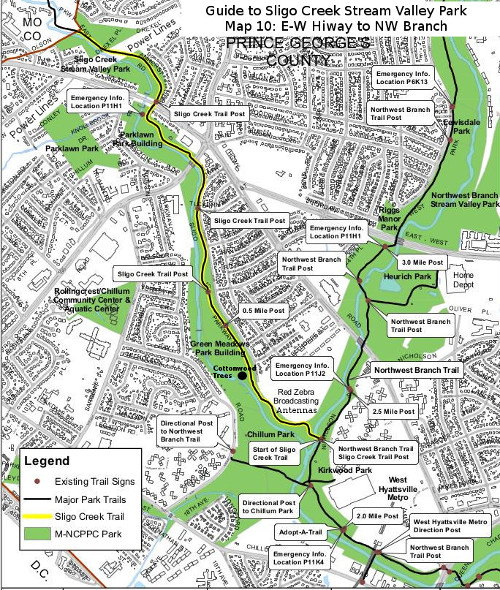 This portion of the hiker/biker trail is 1.5 miles long. After crossing East-West Highway the terrain becomes noticeably flatter. Welcome to the Coastal Plain! From here on out to Ocean City, the Piedmont Plateau disappears beneath the eroded debris of the Appalachians— kind of like what happens to your basement when you live in a house too long. There are no hills for Sligo Creek to carve through, so she meanders here and there through the sand and gravel. Just past the highway, Takoma Branch comes in from the right. Unfortunately there is no trail that can be used to explore this tributary back to its sources in Takoma Park.
After crossing Riggs Road (1.1 miles from Northwest Branch), the stream is confined to a concrete bed for a few hundred feet to keep it from flooding the low-lying neighborhood. The concrete bed is then replaced by a dike for another half mile. To the right of the dike are playing fields that border the creek for about half-a-mile. To the left of the dike a section of road is named Sligo Parkway.
Due to a border of woods, the creek is not visible from the hiker/biker trail. But rather than gliding innocently by, one should venture over to the stream bed for a gander. The stream is broader than ever, and is periodically broken up by nice-looking stone structures designed to channel the creek and slow down its flow during stormy times. There are low places in these dams to allow fish to move up and down the creek. Before the area was extensively settled, shad (a tasty fish) used to migrate up Sligo to spawn in Spring. Due to barriers and pollution they left the scene but still come up nearby Northwest Branch, so one can hope for their return.
Close to the end of the stretch of ball fields, stands a huge old Eastern Cottonwood (Populus deltoides). In late Spring, its cottony flowers are strewn around like a light snow. This area by the creek has the largest concentration of Cottonwoods in the watershed.
As the trail re-enters a wooded area for the first time since crossing East-West Hwy, it crosses a bridge over a small tributary but the trail stays to the left of the creek, which is still not visible from the trail. Just beyond the bridge to the left of the trail, a chain-link fence topped with barbed wire parallels the trail. It protects a complex of antennas erected just after WWII and is now owned by Red Zebra Broadcasting.
After about a quarter-mile of woods and the fenced off area, a bridge suddenly appears. It carries the Sligo hiker/biker trail over Northwest Branch where the trail connects with the Northwest Branch trail. The elevation above sea-level here is about 38 feet, approximately 400 feet lower than the highest reaches of the watershed found back in Wheaton.
By the way, following the Northwest Branch trail downstream less than a mile will bring the traveler to the West Hyattsville Metro Station. Near that same area of the Branch upstream from Queens Chapel Road, one may find 120 million year-old petrified (carbonized) driftwood on the bottom of the creek from the days when the area was covered by a shallow sea.