
Trail Guide Map 5
Colesville Rd to Wayne Ave
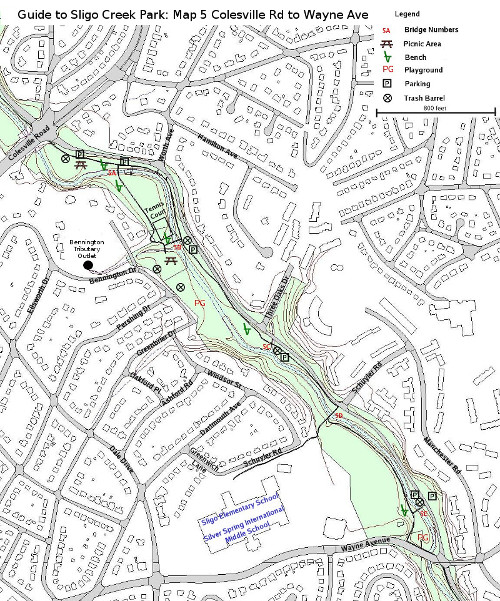
This portion of the hiker/biker trail is 0.7 miles long. If on a bicycle, you will probably want to just follow the paved trail down to Wayne. It stays on the left bank of the creek for about a half mile to where Schuyler Road intersects with the Parkway. There the trail goes over the creek and continues the last two tenths of a mile to Wayne Ave. Unfortunately the creek is often out of sight, and this portion of the trail is rather congested.
Walkers can add some zest to their experience by crossing over the creek at the first footbridge past Colesville Road. The unpaved trail that heads upstream has good views of large rocks and beaches in the creek bed. A paved trail heads downstream past a tennis court to Bennington Tributary. On the walk down, there are a number of attractive trees to enjoy, including a spectacular American Beech (Fagus grandifolia), several White Pines, a Norway Spruce, and numerous large Tulip Trees.
After a walk up Bennington Drive along the tributary for about a quarter of a mile, one can see the above-ground beginning of this branch of Sligo. It consists of two five-foot diameter outlets. Rainfall that hits much of downtown Silver Spring to the east of Georgia Avenue finds its way to this drainage ditch. As one can imagine, since this storm water contains urban run-off, it is a source of regular, and sometimes, really nasty contributions to Sligo. Neighbors keep an eye on the condition of the stream, and often call in problems to the County government. In the FOSC website look under “Water Quality/ Water Watch Dog” for more on this topic. However, this unassuming portion of the waterway is still a place to discover snails, frogs, Mallard ducks cruising its surface, as well as fish such as black-nose dace and white suckers.
Where Bennington Tributary joins Sligo Creek, there is a footbridge that rejoins the main bike path. Staying on the right side, however, a paved trail soon leads to a playground. Leading from the playground, an unpaved rough trail continues downstream to where it connects with the bike path by the footbridge at Schuyler Road. This trail is definitely too rough for bikers but has the virtue of being quite interesting for walkers.
Below the footbridge at Schuyler, the bike path is hemmed in by a chain-link fence to the right and the bank of the creek to the left. On the other side of the fence is the football stadium and track for the former setting of Montgomery Blair High School. The High School was built on the banks of Sligo Creek in 1935, but moved to a location a couple of miles away at the intersection of University Boulevard and Colesville Road in 1998. Sligo Elementary School (mascot, “the salamanders”), and the Silver Spring International School share the renovated buildings of “Old Blair".
Just before Wayne Avenue, the bike path goes through a small playground. If you know your trees, you might identify a good-sized Swamp White Oak (Quercus bicolor) growing close to the creek. It is the only known example of that oak in the park. Wayne Avenue may eventually carry the “Purple Line” across Sligo Creek, but at this time (October 2016) construction has not started.