

Keith Kozloff
March 25, 2015
A Walk in Takoma Branch
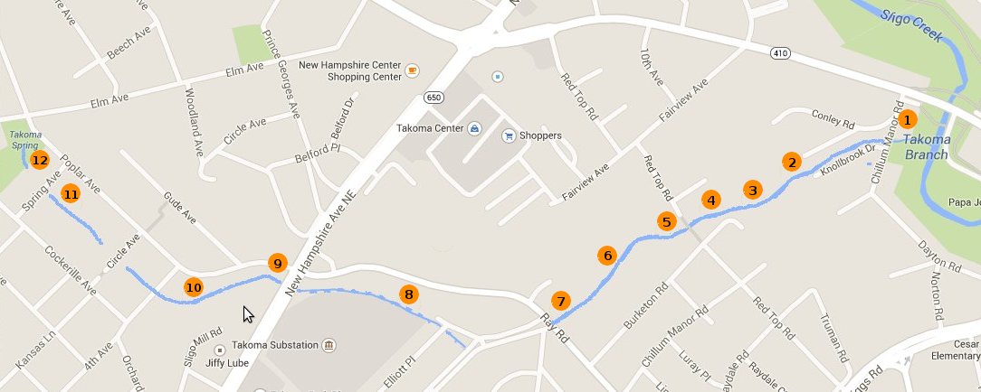
On March 12, Clair Garman and Keith Kozloff conducted a walking survey of Takoma Branch in order to update available information about its source and visual ecological conditions. Because we were more certain about where Takoma Branch ends than where it starts, we walked upstream. Accordingly, we will describe the conditions of Takoma Branch from its confluence to its source. As we walked upstream, the conditions of both the stream itself and surrounding land varied greatly, which we show through a series of numbered photos whose links are embedded in the text below.
We began the walk where Takoma Branch joins the main stem of Sligo Creek just off Highway 410 near Riggs Road in PG County. Takoma Branch is not readily accessible in the area directly upstream of the confluence due to heavy undergrowth and vines (photo link 1). Not much further along, however, the bottom land opens up to an open area of mature forest that is eventually bounded by single family residences (photo link 2 and photo link 3). The forested area surround Takoma Branch gradually narrows as we proceeded upstream. We met a couple who were on their back porch, which overlooks that stretch. They explained that the concrete structure in the stream covers a WSSC pipe (photo link 4) expressed interest in participating in local clean-up activities.
We then passed a wooden footbridge connecting two dead ends of Red Top Road (photo link 5). After the footbridge, Takoma Branch remains surrounded by forested area (photo link 6). Further upstream, it enters a culvert under Ray Road (photo link 7) and remains underground for about a block where it appears that PG County made surface changes to improve local drainage. Takoma Branch emerges in the form a concrete channel that offers little ecological value (photo link 8). This channel runs above ground until it goes underneath New Hampshire Avenue.
Takoma Branch emerges as a more natural flow on the other side of New Hampshire in an overgrown area (photo link 9) where two branches join together from two upstream springs that constitute its sources. The main branch emerges from a culvert at the south end of Circle Woods remains above ground until Spring Avenue (photo link 10 and photo link 11). It is underground again until the spring in Spring Park (photo link 12). The minor branch runs along the side of the McLaughlin School and originates at the boxed spring located at the southern end of McLaughlin Woods.
Overall, Takoma Branch is classified as "severely impaired" by Metropolitan Council of Governments (COG). We are in the process of collecting information about previous restoration and management activities as well as points of contact in the City of Takoma Park, PG and Montgomery Counties, and neighborhood associations.